www.ilpiola.it
Roberto Piola
Work
Tom Tom
Sorry, English only page
An altimeter for TomTom
Good bye Tomtom, welcome Wheredroid
April 2011: The newest tomtom 1000 are extremely closed, i.e.: they no longer accept to run unofficial software. I moved to the Android platform for re-starting from scratchImportant notice
If you are experiencing problems with the latest 7.xx and 8.00 versions of the tomtom firmware (i.e.: if the altimeter icon does not show at all in the menu, please read here.If you are experiencing problems with version 8.30 of the firmware, I'm workingon that; please be patient!
And now, what is it?
The TomTom GPS chipset can derive the altitude from the GPS data, provided that at least 4 satellites are in view (3 non-aligned satellites suffice to compute the position on the surface, not the altitude); however, the standard TomTom Software never displays it.My first big piece of code for the TomTom does exactly this: extract altitude data from TomTom chipset and display it:
Compatibility
As from version 1.06, it should work with any Tomtom model (i.e.: the physical devices, NOT on the tomtom software that installs on a PDA; if you are interested in a PDA version, look here), with firmware up to version 7.x (I had a report of malfunction with firmware version 8... I'm investigating about it).Caveats
- The precision in altitude extracted from GPS is not very high. It is about one third of the resolution relative to the surface (i.e.: if a GPS receiver has a 10 m precision for measuring latitude and longitude, it will have a 30 m precision when measuring altitude), and is inherent to the altitude computation. If you want a better accuracy, a barometric altimeter is much more precise. However, Tomtom precision is sufficient when you go on a mountain and you want to know hou much you still have to climb before reaching destination.
- The altitude derived from satellite positions is given "above the ellipsoid", i.e.: relative to the perfect shape traced by the satellite orbits. Usually the altitude is given "Above the sea level", i.e.: above the shape that the earth would have if it were covered by water; it is a shape called "the geoid", an ellipsoid with some bumps. The difference is small (in Turin, Italy, the geoid is 48.1 meters above the ellipsoid), but you must take it into account. It appears that the TomTom Rider and the ONE can read from satellites the height of the geoid so that we can correct the altitude, while the GO, GO/300 and GO/700 can not. The altimeter will show an asterisk (*) next to the altitude if it can not read the correction from satellites. You can correct the altitude manually by using the "Set wildtom preferences" menu item.
Revision history
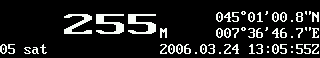
- 1.00 - March 24, 2006: version 1.00 is out!
- 1.01 - April 5, 2006: version 1.01 is out: added battery display and fixed some bugs with shutdown and console output
- 1.02 - May 6, 2006: version 1.02 is out: added heading and speed display
- 1.03b3 - June 1, 2006: the public beta 3 for version 1.03 is out: modified in order to be compatile with the GO 700, modified activation keys, added the ability to switch from metric to british units
- 1.04 - July 28, 2006: version 1.04 is out: more resistent to "No data" / "No signal" conditions; moved a small little the battery indicator to the right; fixed a bug in altitude display when the number of satellites drops below 4 and british units are selected; altitude graph display
- 1.05 - January 16, 2007: version 1.05 is out: fixed some problems with new firmwares.
- 1.06 - October 21, 2007: version 1.06 is out: I had a very hard time to make it compatible with newer tomtom models (520/720/920/One XL), and I also added the displaying of the vertical direction (climbing or falling)
- 1.07 - April 21, 2008: version 1.07 is out: just a minor change: the battery indicator now works again with new versions of the firmware.
- 1.08 - June 16, 2008: version 1.08 is out: now it uses the whole width of the screen when run on large-screen units.
- 1.09 - January 5, 2009: version 1.09 is out: now it allows you to set a fixed correction to the altitude.
- 1.10 - September 21, 2009: version 1.10 is out: now it allows you to display UTM coordinates, and fixes compatibility problems with firmware version 8.30
- 1.10d - November 18, 2010: version 1.10d is a latest bug fix that, in some cases, runs even on the newest 9xx tomtoms. However, my TT 970 has been stoled, and the newest tomtom 1000 are extremely closed, i.e.: they no longer accept to run unofficial software. I moved to the Android platform for re-starting from scratch
Some funny picture
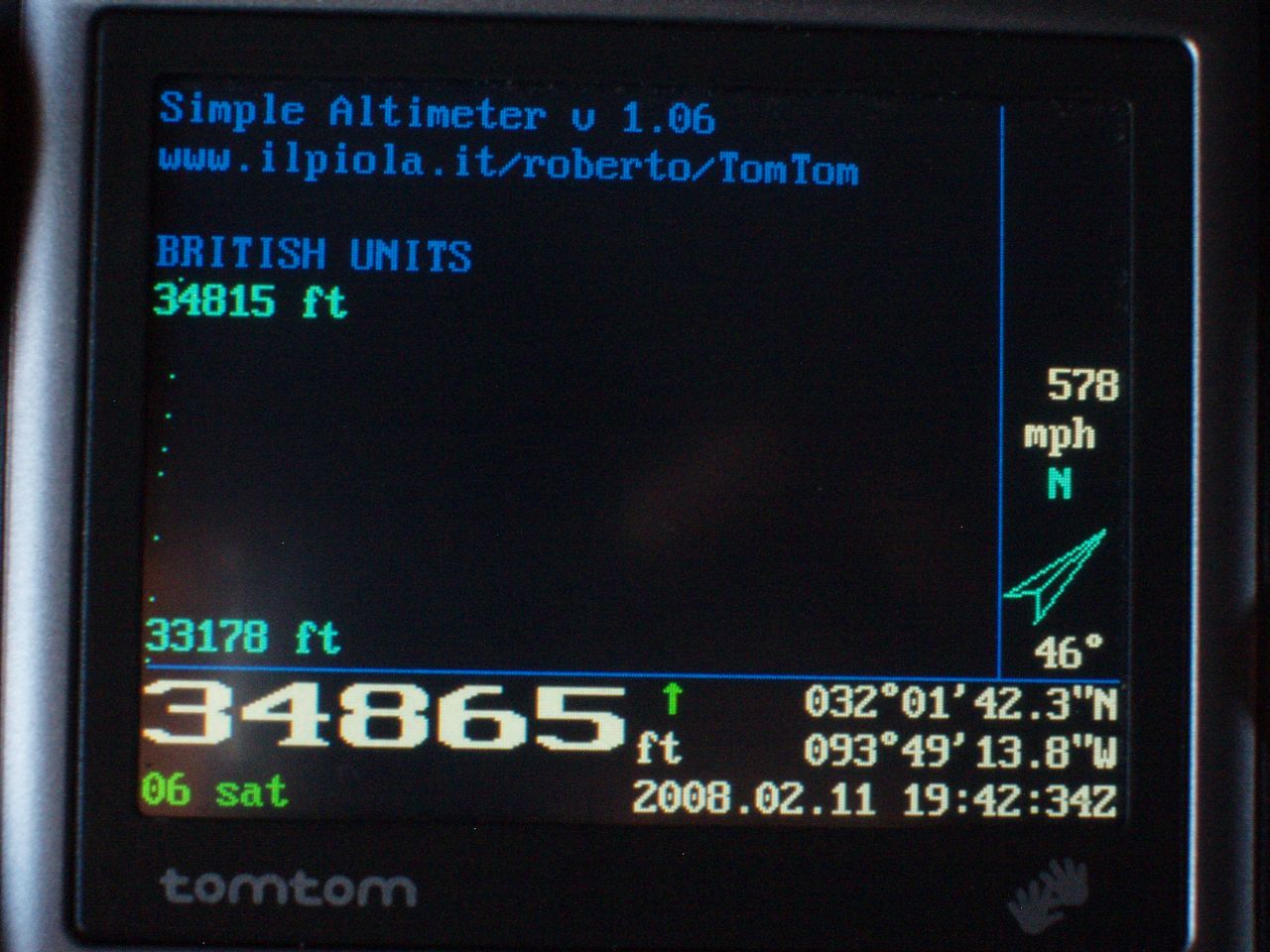
Adam took my altimter on a plane. See it at action: Picture 1 Picture 2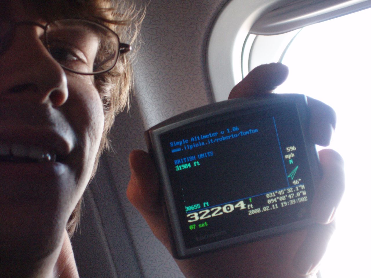
Obtaining it
It is a shareware, you can download \stable version (1.10-20090921) here, or the latest unfinished version (1.10d-20101118) hereIn order to install it, expand the zip file on the root directory of the SD card of your device, or on the root of the internal storage, if your unit has internal storage: it will place the menu item and the icon in the SdkRegistry directory, and will create a /wildtom directory for the executable file. Reboot the TomTom and you will see a new "Simple Altimeter" icon on the menu. Tap on it and you will se the altitude for a while (tap again the screen for returining to normal functionalities). Another icon called "Wildtom Preferences" will allow you to switch between metric and british units.
For a permanent license, you must send me (roberto@ilpiola.it) 5 euros via PayPal, along with the serial number (the 12 letters-and-digits code that is printed on the bottom of the unit, not the 5+5 letters code that is used during map activation) and the model of your device.
I can accept payments via Liberty Reserve as well... please send me the money on account U0897416, then mail me your model, serial number and payment details. Click here if you do not know what Liberty Reserve is.
The license will cover all 1.xx upgrades and fixes, and if you change your device I'll re-issue you a license for the new serial number (provided that you don't change it more often than once a year... it's quite a suspect activity.
Development
Many persons asked me to port it on the PDA (Windows Mobile). I have some skills in programming on the WM platform, I own a Qtek 9090 device (PocketPC that runs on Windows), but I lack a GPS device that can connect to the PDA in order to develop my software. If you have an unused one, and you'd like to lend it to me for the time necessary for the development, I'll be glad to offer you a full license for all versions of the altimeter. Write me at roberto@ilpiola.it if interested.